Water Quality Testing Data on Potomac River, Antipoison Creek
We’ve been working with the Nutrient Analytical Services Laboratory (NASL) at the University of Maryland Center for Environmental Science’s Chesapeake Bay Laboratory for several months now, analyzing water quality in the Potomac River and Antipoison Creek (a small tributary of the Chesapeake Bay on Virginia’s Northern Neck). NASL provides the analytical services for phosphates, nitrates, ammonium, and various forms of chlorophyll (total, active, and phaeophtin), from water samples that we collect, and filter in preparation for analysis. We also measure pH and salinity of these samples. For more on procedures, please see my previous post here.
The sampling sites on the Potomac River are found just north of Riverbend Park’s visitor center. Samples here are collected on foot, with a swing sampler, at three locations (with two samples taken per location, samples “A” and “B” in the data shown below). The Antipoison Creek samples are taken via boat at five or six locations(also with two samples taken per location). Sampling is generally conducted once a month on both bodies of water, or after an extreme precipitation event. Sampling began on Antipoison Creek this past September, and on the Potomac River this past January.
Now that we have a few months of data, we would like to share them here.
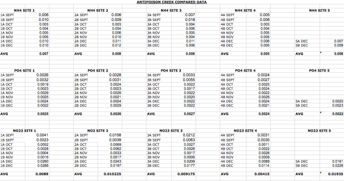
The following is ammonium (NH4), phosphate (PO4), and nitrate (NO23) levels, and their averages, at Antipoison Creek from September to December of 2015. We did not start testing for chlorophyll until December of 2015, and only have one month’s worth of data for those parameters.
The following is ammonium (NH4), phosphate (PO4), and nitrate (NO23) levels, and their averages, on the Potomac River from January and February from this year.
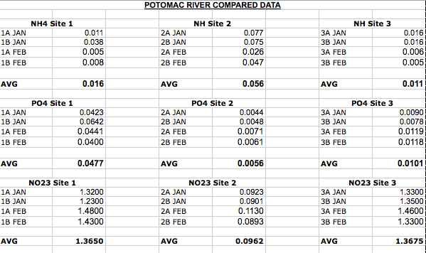
Comparing between sampling locations, ammonium, phosphate and nitrate averages from the Potomac River samples are significantly higher than the Antipoison Creek samples. The Antipoison Creek watershed is rural. There is some agriculture going on in the fields surrounding the creek, along with low-density residential development. Antipoison has a great deal of oyster aquaculture taking place within the creek, with personal oyster floats off residential properties, and a commercial production facility located at the mouth of the creek (with thousands of oysters being grown in the vicinity). This is likely having a significant impact on water quality.
The Potomac River watershed, in the area where we are testing, is much more densely populated. Nutrient levels, such as phosphates and nitrates, might be higher due to higher concentrations of polluted runoff coming from suburban developments. There are also no oysters acting as a natural filtration system in this part of the watershed. It will be interesting to compare chlorophyll levels between these locations once enough data is retrieved and analyzed. We’ll keep you posted!
