Month: March 2014
A Chesapeake Homecoming
Link Posted on Updated on
A recent piece from the New York Times on the Chesapeake oyster industry
Mid-Week News Roundup
Some articles I’ve been reading today from various sources on Chesapeake Bay news:
Chesapeake Bay Program: “Conserving waterfowl habitat at Mallard Haven River Farm”
B’More Green: “Bill to Protect Pax River could scuttle Eastern Shore wind project”
Washington Post: “EPA proposes greater protections for streams, wetlands under Clean Water Act”
And several from the Bay Journal:
“Shell shortage leaves some oystermen unhappy with their options”
“D.C. mayoral candidates take their stance on the environment, Anacostia”
“Virginia puts the brakes on proposed route that would impact wetlands“
How Does Salting Our Roads in the Winter Impact our Waters?
Earlier this week the Northern Virginia area had quite a few inches of snowfall. This was likely one of our last storms now that it’s officially spring. After the snow melts, and the days get warmer, we can still see the impacts of snowstorms on our watershed. This afternoon I’ve been reading the EPA’s blog for Healthy Waters of the Mid-Atlantic Region on the impacts of road salt on our streams, rivers, and the Chesapeake Bay. (“Recovering from a healthy does of winter“).
The impact of salt runoff is greater in freshwater systems than saline. The Bay has a mix of freshwater and saltwater estuaries. The more saline waters and species are less likely to be affected by salt runoff. However, in freshwater, salt can lower oxygen levels and increase conductivity, directly impacting aquatic life and macroinvertebrates. Salt runoff can also affect human drinking supplies and human health, should concentrations get too high.
The post includes tips on how to remove excess salt from driveways and roads, and links to previous advice on smart ways to apply salt, with minimum impact (for future reference).
Winter Rains May Predict Oyster Success
Link Posted on Updated on
Winter Rains May Predict Oyster Success
Scientists with the Maryland Sea Grant are studying the relationship between oyster abundance and winter climate. Their findings could help predict oyster success, dependent on winter rains and average seasonal temperatures.
Recent Environmental Legislation from Maryland
The Baltimore Sun’s environmental blog, B’More Green, has two stories this week on recent and proposed legislation in Maryland.
The first deals with the development of wind farms across Maryland and the Chesapeake region: House OKs energy project on preserved farmlands.
The second is an attempt by Maryland senators to stall regulation limiting phosphorus, a pollutant for the Bay: Senators seek to stall pollution regulations.
The senators claim they’re protecting state farmers in delaying regulation. Maryland, and the Eastern Shore in particular, is home to many poultry farms, which contribute a significant amount of phosphorus to the Chesapeake Bay. Limits on phosphorus were proposed in 2011; implementation has been delayed to the current day.
The B’More Green article reminded me of a piece I heard on NPR earlier this year on the links between agriculture, phosphorus and pollution. The piece outlines the economic consequences of implementing limits on phosphorus: the impacts on Maryland farmers, and on consumers as well. But it also highlights how the continuation of large-scale agricultural activities in the region can pose a serious risk to water quality.
Chesapeake Bay Dead Zone
The Chesapeake Bay Program summarized the results of a study on nutrient loading in the Chesapeake Bay on their site last week. The study, by Yuntao Zhou, Donald Scavia, and Anna M. Michalak, found that the Chesapeake Bay’s annual dead zone’s size and severity has remained unchanged in recent years, the duration of the dead zone, however, has declined over time. The report in Limnology and Oceanography also examines the role of meteorological factors in the development of dead zones.
Declining Planting Rate for Forested Riparian Buffers
Link Posted on
Declining Planting Rate for Forested Riparian Buffers
After posting yesterday about tree cover in the Chesapeake region, I came across this article from the Bay Journal on riparian forested buffer zones. According to author Karl Blankenship, streamside tree planting rates are falling. Forested buffers improve stream health, and help states in the Chesapeake watershed reach Bay cleanup goals. The six states, and the District of Columbia, which make up the Chesapeake Bay watershed, have pledged to plant 15,000 miles of forested buffers by 2025; yet last year only 202 miles were planted. Blankenship outlines the implications of this declining rate of planting, and looks at what needs to be done to turn the trend around.
Forest Watch in Chesapeake Region
The World Resources Institute’s Global Forest Watch runs a mapping application that monitors forest cover across the globe. I have been looking at the Chesapeake Bay region and using the different tools to examine tree cover in the region, and loss and gain of tree cover from 2000-2013.
I expected there to be more loss of tree cover, believing there to be a rise in development around the Chesapeake Bay over the last decade. The data comes from the University of Maryland, which defines tree cover loss as “the complete removal of tree cover canopy at the Landsat pixel scale.” The application looks at major changes, such as the loss of tree cover though disease, fire, or timber harvesting. I’m not sure, but the map may not be picking up on smaller scale activities, such as home building.
Overall there seems to be a lot of simultaneous gain and loss, on the Virginia side of the Chesapeake, and more gain over the last thirteen years on Maryland’s Eastern Shore.
If a user wants to look at a specific area more closely, he or she can examine forest use and conservation. Users are also able to submit their own stories and data to document change in a particular region. I’ve posted the link below:
Global Forest Watch
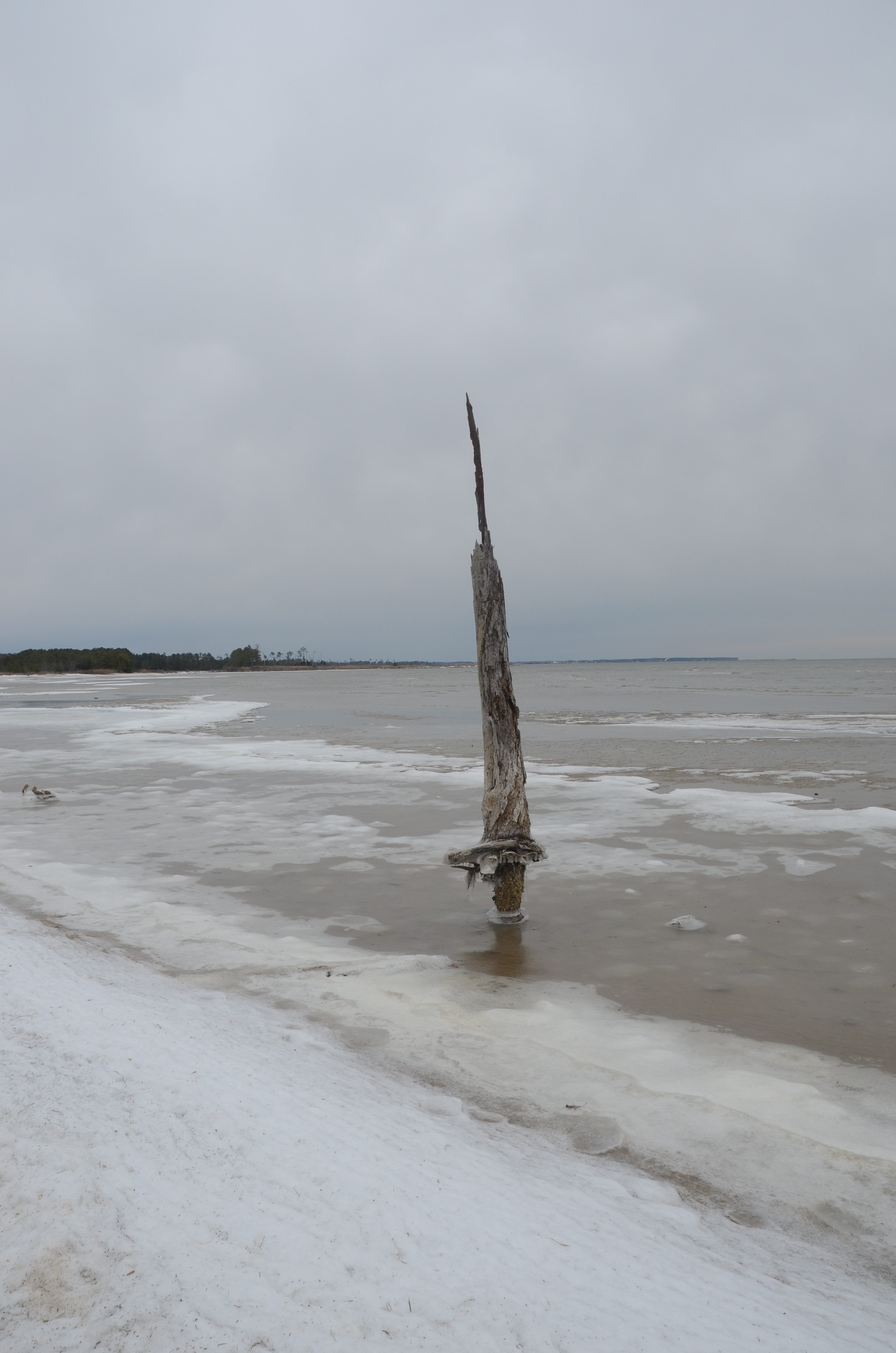
The State of Virginia’s Wetlands
A look at how sea level rise is affecting two Virginia marshes, Dameron Marsh and Hughlett Point, and what this means for the future of wetlands in Virginia’s Chesapeake Bay region:
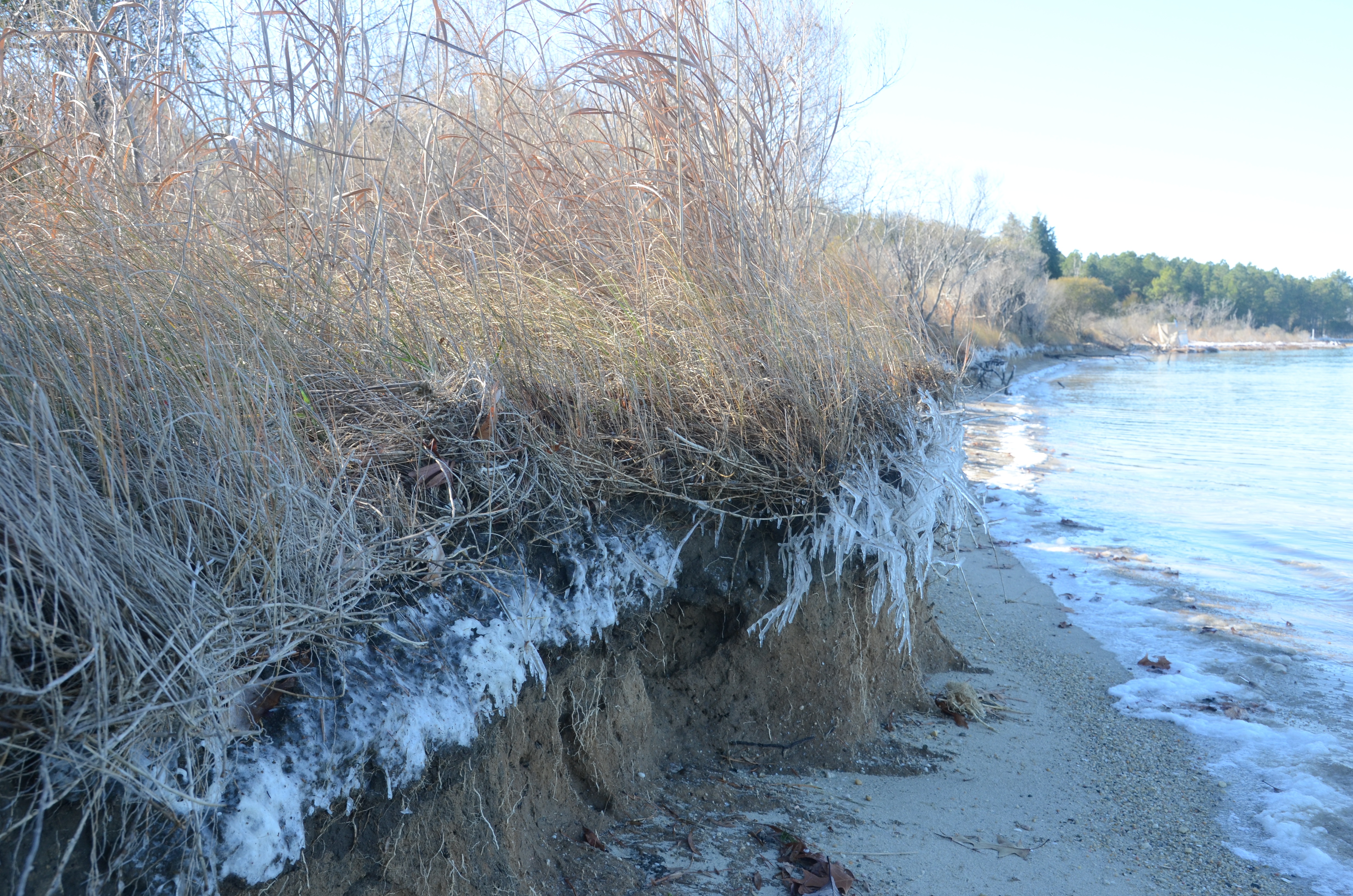
Additional photos from Dameron Marsh
and Hughlett Point
