Forest Watch in Chesapeake Region
The World Resources Institute’s Global Forest Watch runs a mapping application that monitors forest cover across the globe. I have been looking at the Chesapeake Bay region and using the different tools to examine tree cover in the region, and loss and gain of tree cover from 2000-2013.
I expected there to be more loss of tree cover, believing there to be a rise in development around the Chesapeake Bay over the last decade. The data comes from the University of Maryland, which defines tree cover loss as “the complete removal of tree cover canopy at the Landsat pixel scale.” The application looks at major changes, such as the loss of tree cover though disease, fire, or timber harvesting. I’m not sure, but the map may not be picking up on smaller scale activities, such as home building.
Overall there seems to be a lot of simultaneous gain and loss, on the Virginia side of the Chesapeake, and more gain over the last thirteen years on Maryland’s Eastern Shore.
If a user wants to look at a specific area more closely, he or she can examine forest use and conservation. Users are also able to submit their own stories and data to document change in a particular region. I’ve posted the link below:
Global Forest Watch
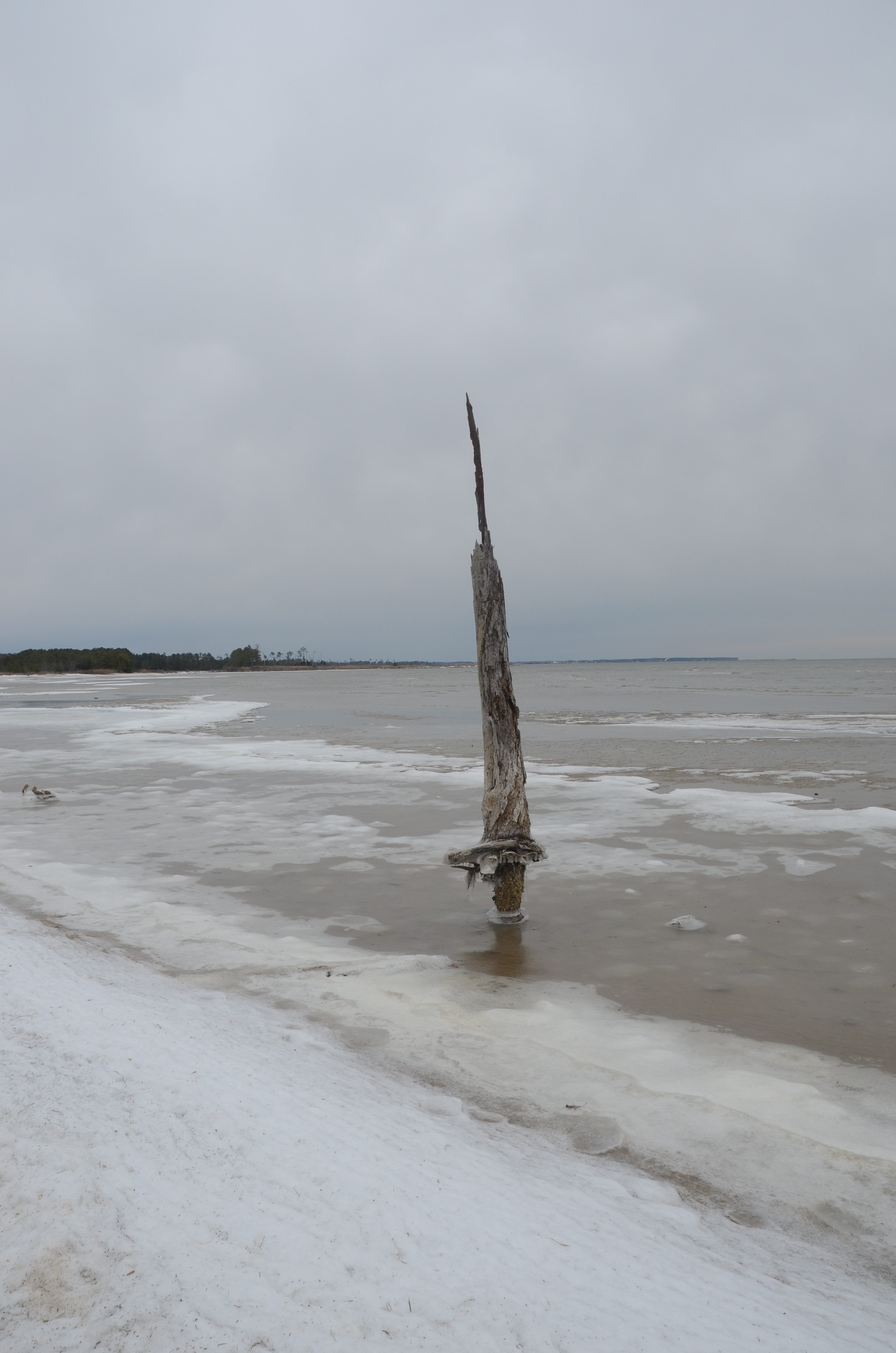
The State of Virginia’s Wetlands
A look at how sea level rise is affecting two Virginia marshes, Dameron Marsh and Hughlett Point, and what this means for the future of wetlands in Virginia’s Chesapeake Bay region:
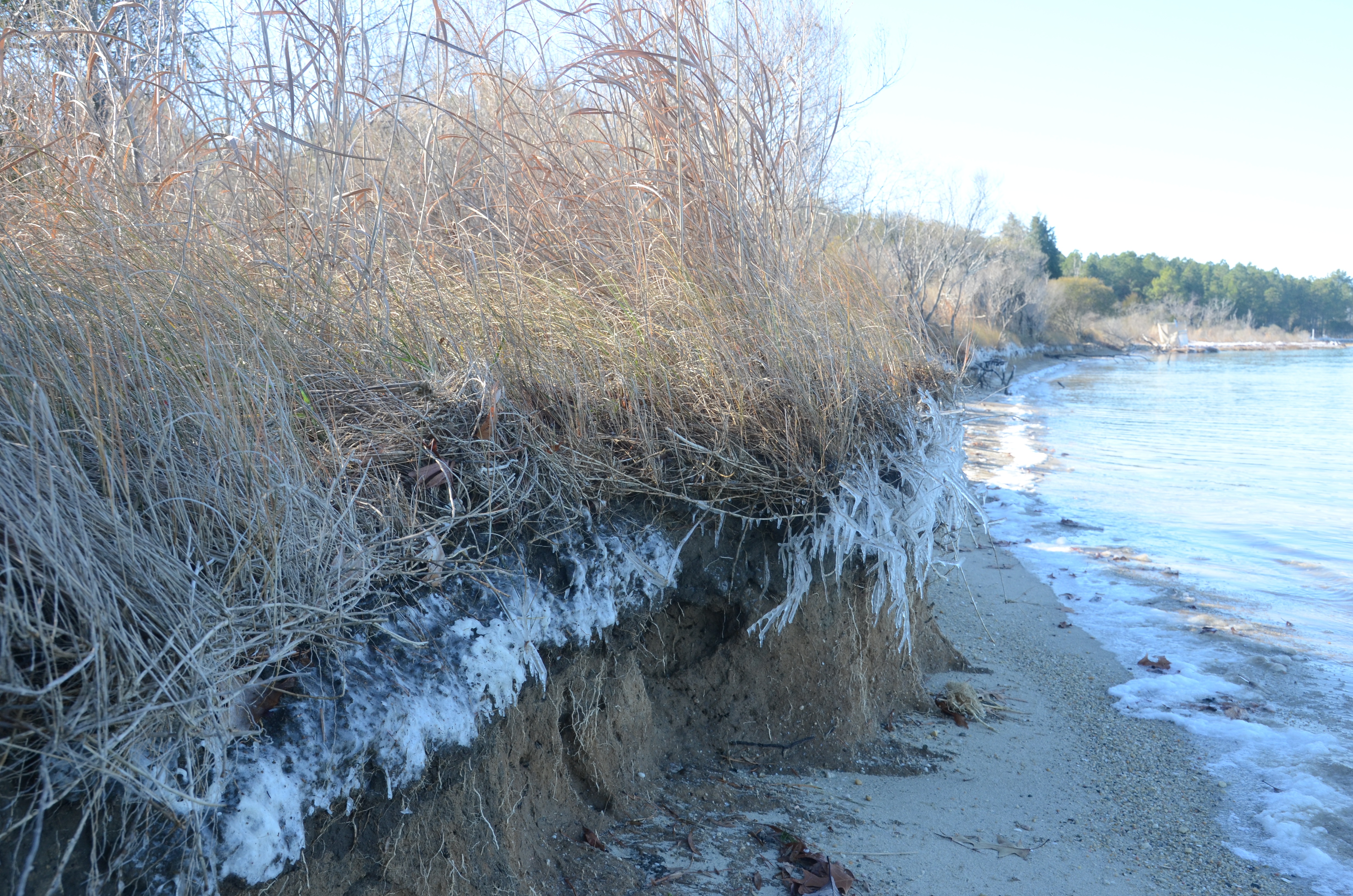
Additional photos from Dameron Marsh
and Hughlett Point
Chesapeake Bay Program Report on Water Quality Improvements
Link Posted on
Chesapeake Bay Program Report on Water Quality Improvements
The Chesapeake Bay Program recently released a report on the improvement of water quality in the Chesapeake. Using evidence from 40 different case studies on the watershed, the report examines how best management practices (BMPs) have reduced sediment loads and atmospheric nitrogen deposition. Specifically, an improvement in methods used in agriculture, at wastewater treatment plants, and better control of power plant and vehicle emissions have positively impacted the Bay.
The report also details current challenges associated with implementing BMPs (with a focus on population growth and intensive agriculture in the region), while looking at further opportunities for water quality improvement.
Chesapeake Stormwater Network’s Homeowner Guide
This afternoon I’ve been reading about the Chesapeake Stormwater Network and looking over their Homeowner Guide for a More Bay-Friendly Property. The guide goes into projects and practices such as rain gardens, rain barrels, planting trees, rain permeable driveways and conservation landscaping.
Reading for some starter tips on potential spring projects:
Friday News Roundup
Virginia’s Northern Neck Soil and Water Conservation District briefed on consequences of hydraulic fracking, proposed in the region: (Rappahannock Record).
Secretary of Natural Resources for the Chesapeake Bay Appointed in Virginia: (Bay Journal)
Rally at Cove Point, Maryland to protest export of natural gas: (Baltimore Sun)
Pennsylvania’s Department of Environmental Protection hears responses to Chesapeake Bay Watershed Agreement: (PA Environment Digest)
More on Ocean Acidification and the Cheapeake Oyster
Last week I shared a project on the state of the Eastern oyster, which included a review of restoration efforts in the Chesapeake region and a study on the potential impact of ocean acidification on the oyster population. As I mentioned in this report, acidification has had a major impact on the West Coast oyster industry, but has not yet had much of an effect on the East Coast. It is difficult to predict how the Chesapeake Bay will be affected by acidification, given the unique estuary that the Chesapeake is. The Bay is a mix of freshwater and saltwater, and salinity and depth vary across the estuary. Although many reports on ocean acidification exist, there are very few studies that have been conducted on acidification on coastal systems.
I learned today of a professor who has been studying the issue of acidification, and its effect on species native to the Chesapeake, such as the Eastern oyster and blue crab. Justin Ries works at the Marine Science Center in Northeastern University in Boston, and has been growing oysters and blue crabs in the lab. The organisms have been raised in water with high levels of carbon dioxide, to mimic possible future conditions on the East Coast. The results don’t look so promising for the now growing Chesapeake oyster industry. (See a 2010 Earth Magazine write-up here).
However, as mentioned, there is uncertainty as to the extent acidification will affect the Chesapeake. More studies must be conducted on coastal estuaries to be able to predict future conditions. In the meantime, representatives in the state of Maryland are attempting to bring this issue up for further study, examining the effects of acidification, and possible solutions, to be included in a report by the Maryland Department of Environment next year, (Maryland House Bill 118). Hopefully other states, especially Virginia, will follow suit.
Restoring Wetlands to Act as Carbon Sinks
Link Posted on Updated on
Restoring Wetlands to Act as Carbon Sinks
A report released by Restore America’s Estuaries, describes how wetlands can be used as carbon sinks to offset the impacts of climate change. The study focuses on a region on the West Coast, but there is a lot of potential for wetland restoration in the Chesapeake Bay area. The Chesapeake has many wetlands, several of which are in danger of disappearing. Could and should we restore wetlands in the Chesapeake region to act as carbon sinks? Which sites would be suitable for restoration?
The Restore American’s Estuaries Report: http://www.estuaries.org/images/stories/RAEReports/snohomish_report.pdf.
Tunnel Under D.C. Will Reduce Flow of Sewage into Local Waters
Link Posted on Updated on
Tunnel Under D.C. Will Reduce Flow of Sewage into Local Waters
The Washington Post covered a story in Sunday’s paper on a solution to sewage overflow into local rivers. Workers are constructing a tunnel under Washington D.C., using a machine, “The Lady Bird,” to take up the soil. The end product will be a 13 mile long sewer tunnel, to prevent the flow of untreated sewage to the Potomac and Anacostia River, and to Rock Creek, which frequently occurs with the overburdened combined sewer system in the District.
This tunnel could do a lot to clean up the local rivers, and reduce the flow of polluted water into the Chesapeake Bay. The Post states that all the soil collected by the Lady Bird will be transported to a dumping site in Maryland. My question however, is what happens to all this excess soil? Is there risk of the soil reentering the watershed through runoff, and how much of a risk could this pose?
A Way to Reduce Nitrogen Runoff from Farms in the Chesapeake Watershed?
Link Posted on Updated on
A Way to Reduce Nitrogen Runoff from Farms in the Chesapeake Watershed?
The Bay Journal published an interesting article this week, looking at a way to reduce nitrogen from Maryland farms, using a bioreactor to filter runoff. The method has been used in the Midwest, and is currently being tested in the Chesapeake region.
Update on Virginia Runoff Bill
Several weeks ago I shared an appeal from the Potomac River Conservancy, asking Virginians to contact their lawmakers about legislation on polluted runoff. Virginia passed stricter regulations for polluted runoff several years ago, but has failed to successfully implement these standards. Recent bills attempted to prolong the delay of stronger runoff regulations, but the bills were overturned in the state House and Senate last week. State localities must abide by the new runoff standards as early as July 1. Good news for Virginia’s waterways and for the Chesapeake!
